In AD 43, the emperor Claudius sent an invasion force of four legions, under the general Aulus Plautius, across the Channel to Britain. Rome already knew the island. Julius Caesar had landed twice, in 55 and 54 BC, but had not stayed. This time Rome meant to stay, and its rule lasted until around AD 410.
The Britain the legions found had no single ruler. It was divided among peoples the Romans called tribes, each with its own leaders, lands and loyalties. Some made alliances with Rome; others fought it for decades. Which people held your part of the country shaped what happened there when the Romans arrived.
The ancient British tribes were regional communities and kingdoms whose names survive in classical accounts, coinage and the names of Roman administrative districts. The Trinovantes, Durotriges, Iceni, Cornovii, Silures, Demetae, Ordovices and Brigantes encountered Rome in different ways. You can still follow their stories through eight groups of locations in England and Wales.
From Colchester to a fort on the Menai Strait, follow the Roman conquest location by location, and see which peoples held the land before it arrived.
The conquest of Britain is usually told as a story of emperors and generals. On the ground it was different at every step. Rome reached some peoples with an army and others with a treaty, and took more than thirty years to get from the invasion of AD 43 to the far north-west of Wales. What it left behind still shapes those locations. Here are eight of them, moving out from the south-east towards the far west and north.
The words and names you will meet
- Iron Age: the period before the Roman conquest, when Britain's peoples worked iron, farmed and built hillforts.
- Hillfort: a hilltop settlement defended by banks and ditches.
- Henge: a much older circular monument of a bank and ditch, built thousands of years before the Romans.
- Legion: a unit of around 5,000 Roman citizen soldiers, the core of the army.
- Legionary fortress: a legion's permanent base.
- Auxiliaries: soldiers recruited from peoples across the empire who were not Roman citizens, often posted in smaller forts. Thracian auxiliaries came from what is now Bulgaria.
- Governor: the man Rome appointed to run Britain and command its army, such as Ostorius Scapula or Agricola.
- Client relationship: an arrangement in which a British ruler kept power by staying loyal to Rome.
- Civitas: a self-governing district Rome created for a British people. Its civitas capital was the town that ran it.
- Forum and basilica: a town's public square and the great hall beside it, used for courts and business.
- Amphitheatre: an oval arena for shows and spectacles.
- Tacitus and Suetonius: Roman writers whose accounts of the conquest survive. Suetonius Paulinus, the governor who defeated Boudicca, is a different man from Suetonius the writer.
- Boudicca: queen of the Iceni, who led a great revolt against Rome in AD 60 or 61.
- Caratacus: a British leader who fought Rome for years until he was handed over in AD 51.
- Cartimandua: queen of the Brigantes, an ally of Rome.
Roman names for the towns in this article: Camulodunum is Colchester, Londinium is London, Verulamium is St Albans, Durnovaria is Dorchester, Venta Icenorum is Caistor St Edmund, Viroconium Cornoviorum is Wroxeter, Isca is Caerleon, Venta Silurum is Caerwent, Moridunum is Carmarthen, Segontium is Caernarfon and Isurium Brigantum is Aldborough.
Who were the ancient British tribes
“Tribe” is a convenient description, but these communities were not all organised alike. Some formed kingdoms or confederations, and their territories changed. Many names and geographical descriptions come from Greek and Roman writers, including Ptolemy, who wrote in the second century AD. They do not provide a precise map of Britain on the eve of the invasion.
The eight groups below are selected examples, not a complete list. The Catuvellauni and Atrebates also feature in the invasion story; the Dobunni, Dumnonii and other peoples occupied further territories. The University of Warwick’s guide to Iron Age tribes explains why tribal boundaries remain approximate.
| Tribe | Approximate region | Locations in this article | Relationship with Rome |
|---|---|---|---|
| Trinovantes | Essex and neighbouring eastern areas | Colchester | Earlier diplomacy; participation in Boudicca’s revolt |
| Durotriges | Dorset and neighbouring areas | Dorchester and Maiden Castle | Conquest and subsequent civilian administration |
| Iceni | Norfolk and surrounding East Anglia | Caistor St Edmund | Client relationship followed by rebellion |
| Cornovii | Shropshire and neighbouring Marches | Wroxeter | Military occupation followed by a civic capital |
| Silures | South eastern Wales | Caerleon and Caerwent | Prolonged resistance followed by occupation |
| Demetae | South western Wales | Carmarthen | Roman administration; terms of submission uncertain |
| Ordovices | North western Wales | Caernarfon | Resistance and Agricola’s punitive campaign |
| Brigantes | Much of northern England | Aldborough | Alliance under Cartimandua; later military conquest |
Regions are approximate and changed over time. A town associated with a Roman civitas should not automatically be called its tribe’s pre-conquest capital. A civitas was a community and administrative district; its capital provided a centre for government and civic life.
Colchester and the Trinovantes
 Tanya2501 / CC BY-SA 3.0 / Wikimedia Commons
The Trinovantes of Essex were among the most powerful tribes in pre-Roman Britain, and they had sought Roman protection against the expansionist Catuvellauni as far back as the campaigns of Julius Caesar. By the time of the Claudian invasion, Camulodunon had become a centre of Catuvellaunian power under Cunobelin. Colchester's history therefore involves shifting political control before Rome established its colony.
After the invasion of AD 43, a legionary fortress went up on the site. In AD 49, it became a town for retired soldiers. A vast temple to Claudius followed around AD 54, the year of his death; it became the centre of the imperial cult in Britain. Its base now lies under the Norman castle. For the Trinovantes, it meant the loss of tribal lands, and that heavy-handed land-taking helped fuel what came next. In AD 60 or 61, Boudicca's rebels destroyed the town and the temple became a principal target.
The Historic England record for Colchester Castle and the Temple of Claudius, list entry 1002217, records the sequence of fortress, colony, and temple.
Colchester was rebuilt and flourished in the 2nd and 3rd centuries. One remarkable burial at Abbey Field gives you a glimpse of the people who lived there long after the flames.
The later Roman burial group included a jet figurine of a standing bear, a silver lunula pendant, a silver ring set with a red stone intaglio, melon beads, and a Rhenish ware beaker with the letters BIBE. It means “drink” in Latin. Nina Crummy discusses the burial, C2 F166, in Bears and Coins. The objects belong to later funerary practice rather than to the invasion itself.
Dorchester and the Durotriges
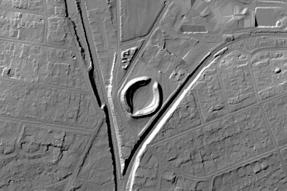 LiDAR: laser scans taken from the air show the shape of the ground with trees and buildings stripped away, so old banks, ditches and boundaries stand out. © Environment Agency copyright and/or database right 2024. All rights reserved.
The Durotriges of Dorset faced the advance of the Second Augustan Legion. Suetonius says the future emperor Vespasian fought thirty engagements in Britain, subdued two powerful tribes, and captured more than twenty towns. That is an account of his wider British campaign, not a count of battles against the Durotriges alone. See Suetonius, Vespasian 4, in Warwick’s ancient source booklet.
Maiden Castle, about 3 km southwest of Dorchester's centre, was a major Iron Age stronghold. Mortimer Wheeler interpreted burials at its eastern entrance as a war cemetery of defenders killed by the Romans. A 2025 reanalysis, including radiocarbon dating, found that the deaths spanned multiple generations. The burials should no longer be presented as proof of a single Roman assault.
Durnovaria became a civilian settlement and an administrative centre for the Durotriges. Its first defences were an earth bank and ditch, built around AD 130. Stone walls came later, after AD 300. The sequence is recorded in Historic England’s Town Walks entry, 1001594.
The Romans reused what they found. At Maumbury Rings, a Neolithic henge was adapted into an amphitheatre. Sections of a Roman aqueduct survive outside the town, and a town house lies in Colliton Park. The Maumbury Rings record, list entry 1003204, documents the henge and its later use.
Caistor St Edmund and the Iceni
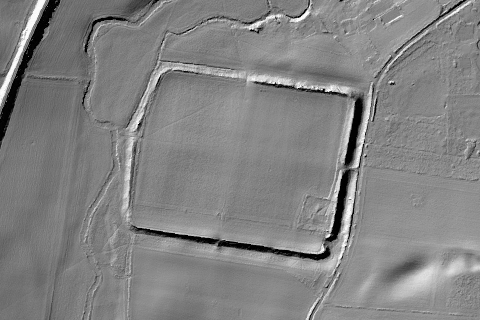 LiDAR: laser scans taken from the air show the shape of the ground with trees and buildings stripped away, so old banks, ditches and boundaries stand out. © Environment Agency copyright and/or database right 2024. All rights reserved.
The Iceni of Norfolk began the conquest period in a client relationship with Rome. When their king Prasutagus died, Tacitus reports that Roman officials annexed the territory, flogged his widow Boudicca and assaulted her daughters. The rebels sacked Camulodunum, Londinium and Verulamium before Suetonius Paulinus defeated them.
Venta Icenorum, about 8 km south of Norwich at what is now Caistor St Edmund, was probably laid out, with its first streets surfaced, in the first half of the 2nd century. Excavation has found little evidence of Iron Age activity within the later walled town itself. It was a newly built, sparsely populated town focused on administration and trade.
The Caistor Roman Project’s excavation account places the emergence of the street grid in the early second century and describes a more gradual development than a single post-revolt foundation. Its walls survive, and its street grid is visible in cropmarks. Aubrey’s Venta Icenorum record provides the location context.
Wroxeter and the Cornovii
 Nilfanion / CC BY-SA 4.0 / Wikimedia Commons
The Cornovii held the Welsh Marches, on the frontier with the unconquered tribes of Wales. Their territory included the area around the Wrekin, but identifying the hillfort as a formal tribal capital goes beyond the available evidence.
Wroxeter began in the early years of the conquest as a frontier post for Thracian auxiliaries, part of the campaigns of the governor Ostorius Scapula. A cavalry fort was established around AD 47; a legionary fortress followed about a kilometre to the north roughly a decade later. Viroconium Cornoviorum grew into the fourth-largest city in Roman Britain and the civitas capital of the Cornovii.
Only a small village now occupies one corner of it, about 8 km east-south-east of Shrewsbury. Since much of the site was never built over, its baths basilica wall, the Old Work, still stands impressively high. English Heritage’s history of Wroxeter describes the military and civilian sequence. Aubrey’s Wroxeter settlement page connects it with the surrounding landscape.
Caerleon and Caerwent and the Silures
 CC BY 2.0 / Wikimedia Commons
The Silures of South Wales gave Rome sustained military resistance. They fought a prolonged campaign under Caratacus and carried on for decades after his capture in AD 51. Tacitus says that the governor Ostorius Scapula was worn down by their constant raiding. His account appears in Annals 12, especially chapters 33 to 40.
Rome’s answer stands at Caerleon. Isca was the headquarters of the same Second Augustan Legion that had fought in Dorset, moved there around AD 75 during the conquest of South Wales. It became one of only three permanent legionary fortresses in later Roman Britain, with an amphitheatre beside it.
To the east is the other half of the story. Venta Silurum, now Caerwent, was established around AD 75 to 80 as a Silurian settlement: a civilian town with a forum and basilica, and later baths and shops. Its surviving walls and excavated buildings show a different form of Roman occupation from the legionary fortress. Cadw’s Caerwent account records its foundation and development.
So the Silures’ territory acquired both a fortress and a market town. For a fuller explanation of the administrative distinction, see Aubrey’s guide to civitas capitals.
Carmarthen and the Demetae
 Marion Phillips / CC BY-SA 2.0 / Wikimedia Commons
West of the Silures, the story changes. The Demetae of the far south-west left less evidence of resistance in the surviving written accounts. That does not establish that they submitted peacefully or negotiated a treaty. Rome still kept a close eye on them. A fort at Carmarthen was occupied from about AD 75 to at least AD 100, according to Coflein record 92890.
Moridunum became the civitas capital of the Demetae, the westernmost Roman town in Wales. Its amphitheatre survives outside the Roman town defences. The Cadw scheduling report for Carmarthen amphitheatre describes the excavated arena and seating banks. Cadw’s Roman conquest and settlement interpretation plan cautions against treating an apparent lack of forts as evidence of friendly submission.
Caernarfon and the Ordovices
 Rhion / Public domain / Wikimedia Commons
The Ordovices of North Wales resisted long after the south had been brought under Roman control. Tacitus reports that they destroyed most of a cavalry unit shortly before Agricola arrived as governor. Agricola responded with a rapid punitive campaign. Tacitus describes its outcome in sweeping terms, but this is a Roman literary account rather than an independently measured population loss.
Segontium followed around AD 77 to 78, on high ground with a good view of the Menai Strait, designed to hold about a thousand auxiliary infantry and connected by road to the legionary base at Chester. Its timber defences were rebuilt in stone in the first half of the 2nd century, and a large courtyard house with its own small bathhouse went up inside.
Cadw’s Segontium account dates the foundation to AD 77. Aubrey’s Segontium record provides the site location and later development. The one-year variation in dating should not be turned into an exact sequence inferred from nearby coins.
Aldborough and the Brigantes
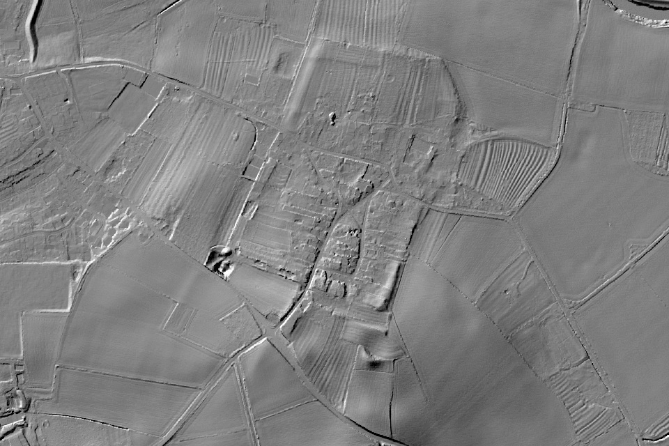 LiDAR: laser scans taken from the air show the shape of the ground with trees and buildings stripped away, so old banks, ditches and boundaries stand out. © Environment Agency copyright and/or database right 2024. All rights reserved.
The Brigantes held much of northern England, the largest tribal confederation in Roman Britain. For years, Rome did not need to conquer them. Their queen, Cartimandua, maintained a client relationship and handed over the fugitive Caratacus in AD 51. Then, around AD 69, her former husband Venutius overthrew her, and the Romans were forced to intervene militarily.
A fort at Roecliffe, near Aldborough on a terrace above the River Ure, belongs to that military world. The town of Isurium Brigantum came afterwards. English Heritage dates the early trading settlement to around AD 70 and the planned civilian capital to around AD 120. It sat on the Roman road network; it had a forum and public baths, and the modern village still keeps part of its street plan.
The English Heritage history of Aldborough distinguishes those phases. The site collection includes a late Iron Age horse-harness pendant, dated between 100 BC and AD 80, that helps connect the Roman town with earlier material culture. Explore Aubrey’s Aldborough record for its wider location context.
A short timeline of the conquest
| Date | Event or development |
|---|---|
| 55 and 54 BC | Julius Caesar’s expeditions to Britain, distinct from the later Claudian conquest |
| AD 43 | Claudian invasion and the beginning of sustained Roman provincial conquest |
| AD 49 | Veteran colony established at Colchester |
| AD 51 | Caratacus captured after Cartimandua hands him to Rome |
| AD 60 or 61 | Boudicca’s revolt destroys Colchester, London and Verulamium |
| Around AD 69 | Venutius displaces Cartimandua; conflict precedes further Roman advance |
| Around AD 75 to 80 | Caerleon’s fortress and Caerwent’s town belong to consolidation in South Wales |
| Around AD 77 or 78 | Agricola’s northern Welsh campaign and the foundation of Segontium |
Sources: the location records linked above and English Heritage’s account of the Roman invasion. Towns continued to develop long after these campaigns; a later object found nearby is not necessarily evidence of the invasion.
What the conquest left near you
Each of these peoples met Rome differently, and each location still shows it: a fortress here, a market town there, an amphitheatre cut into a far older henge. Roads, forts and small finds run far beyond these eight. Research the evidence for tribal territory around your own location, and what Rome left behind when it arrived.
Start with Aubrey’s Roman Britain directory. For research connecting Roman sites with other historical layers, explore a sample location. Aubrey can set a location in its recorded regional context; it cannot establish an exact Iron Age boundary where none is securely known.
Every location has a story. Aubrey finds it.
Sources and interpretation
Classical accounts include Tacitus, Annals 12.33 to 40 and 14.31 to 37; Tacitus, Agricola 18; and Suetonius, Vespasian 4. Archaeological interpretation follows the excavation projects, collections and heritage records linked in the relevant sections. For Colchester’s burial, see Nina Crummy, “Bears and Coins: The Iconography of Protection in Late Roman Infant Burials”, Britannia 41 (2010). For Maiden Castle, see the 2025 study by Martin Smith and colleagues, “Fraught with High Tragedy”, Oxford Journal of Archaeology, DOI 10.1111/ojoa.12324.