History & Significance
Ste. Genevieve sits on the western bank of the Mississippi River in the limestone country of what is now Ste. Genevieve County, Missouri. It was founded around 1735 by French colonists from Illinois Country who crossed the river to take advantage of the fertile bottomland on the western bank for agricultural production, particularly wheat and corn, which they grew on a common field system derived from French agricultural practice. It is the oldest permanent European settlement in what is now the state of Missouri.
The land had been Osage and Illinois Confederation territory. The Illini people, a loose confederation of related Algonquian-speaking groups, had been present in the region for centuries, and the French colonists who came to Ste. Genevieve did so in a context of established French-Illini trade relations that dated back to the late seventeenth century. The Osage Nation's territory extended west from the river, and the French settlement's economic success depended partly on maintaining workable relations with both groups.
The town was originally located in the low bottomland beside the river, an arrangement that proved disastrous. The Great Flood of 1785 inundated the settlement completely and forced the entire community to relocate to higher ground about two miles north, the location of the present town. The move required dismantling and rebuilding the community's structures, a process documented in the French colonial records. Several of the vertical-log buildings characteristic of French colonial construction in Illinois Country survive in the relocated town, making Ste. Genevieve the most complete collection of French colonial architecture in North America.
The town's colonial history spans three regimes. It was founded under French rule, passed to Spanish control in 1770 when Spain acquired Louisiana from France, and was transferred to the United States in 1804 following the Louisiana Purchase. Each regime maintained land records, and the resulting archive of French, Spanish, and American documents for the same parcels is among the most complete multi-colonial land record sets in the country.
The vertical-log buildings and the French colonial tradition
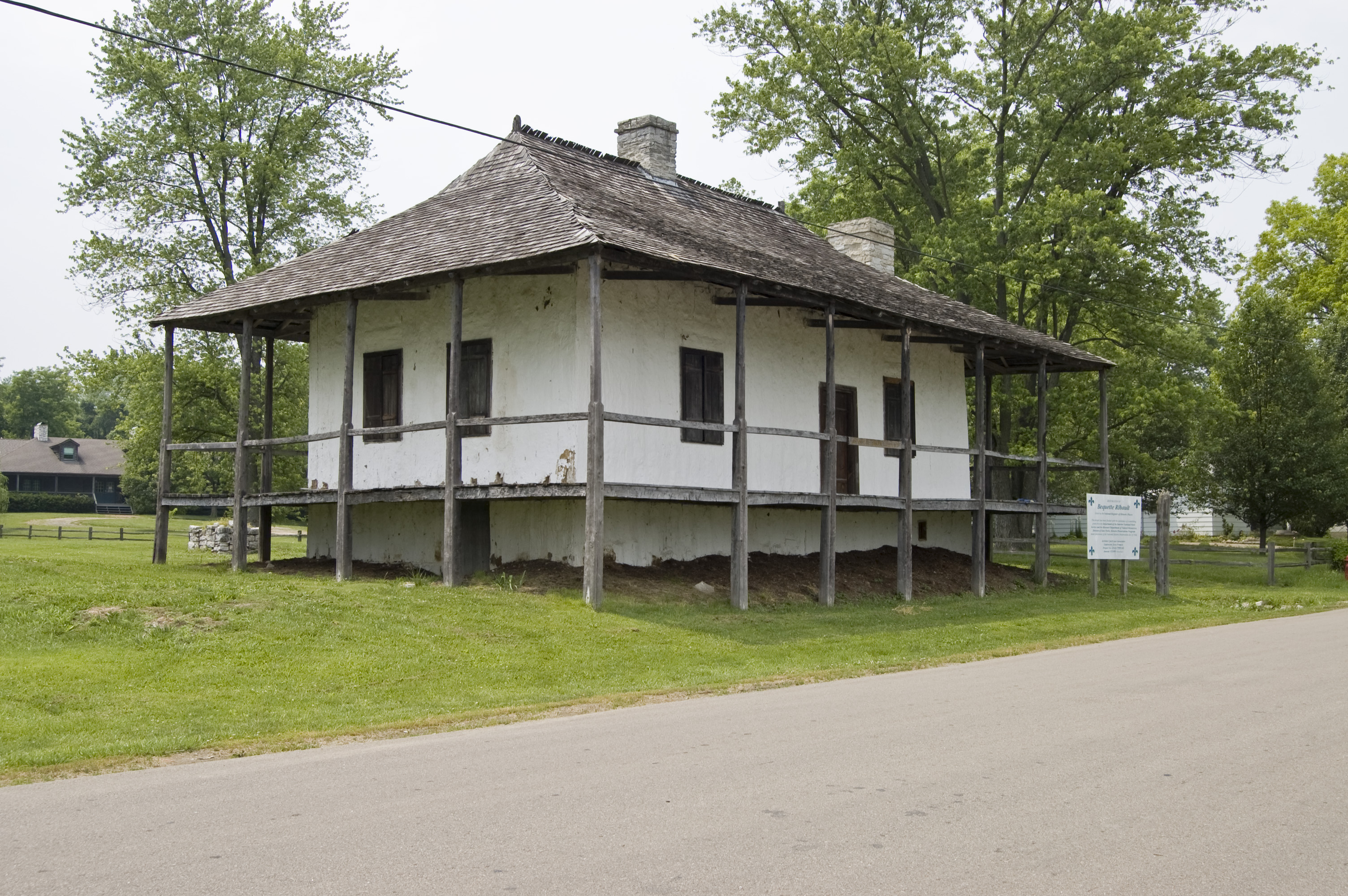
The distinctive architectural feature of French colonial construction in the Mississippi Valley was the poteaux-en-terre system, in which vertical cedar or oak logs were set directly into the ground to form the structural walls of a building. The spaces between the logs were filled with a mixture of clay, straw, and sometimes stones called bousillage. The resulting walls were thick, the interior spaces were cool in summer and retainable in winter, and the buildings were surprisingly durable given their organic construction.
Several examples of poteaux-en-terre construction survive in Ste. Genevieve, including the Bolduc House, built around 1770 and moved to its present location when the town relocated after 1785, and the Maison Guibourd-Valle, built in the 1790s. These buildings are among the oldest surviving French colonial structures in the United States, and they exist partly because the town was too small and too quiet after American acquisition to attract the kind of development that replaced colonial-era buildings elsewhere.
The French colonial records document the labor that built and maintained these structures. Enslaved African workers, enslaved indigenous people, and engagé workers under indentured-style contracts all appear in the French colonial records for Ste. Genevieve. The legal slavery that shaped the French colonial Mississippi Valley was a different legal regime from the English colonial system, governed by the Code Noir issued by Louis XIV in 1685, but its consequences for the people it governed were equally brutal.
The common field system and the agricultural landscape
French colonial agriculture in Ste. Genevieve was organized around the common field system, in which the agricultural land surrounding the town was divided into long narrow strips, each assigned to a household but farmed within a collective framework that coordinated planting, harvest, and the management of common pasturelands. The Grand Champ, the main agricultural common field, was the economic foundation of the settlement.
The long-lot survey system that organized French colonial agriculture is visible in the land records as a series of narrow ribbon-shaped parcels extending back from the river or from the common road, each measured in arpents, the French unit of land measure. These French land surveys were drawn into the American survey system when the General Land Office conducted its surveys after 1804, and the resulting land records preserve the French parcel shapes within the American township-and-range grid.
The transition from French to Spanish to American governance did not immediately disrupt the agricultural system. The common fields continued to operate under Spanish rule, and the legal framework protecting the common field rights was one of the issues the American territorial government had to address after 1804. The Spanish land grants and French concessions that the American government confirmed under the terms of the Louisiana Purchase treaties required the new territorial courts to apply American legal principles to property arrangements that had developed under two different European legal systems.
Three flags, three record systems, one archive
The Ste. Genevieve land records are a document historian's extraordinary resource precisely because the town changed colonial hands twice while maintaining continuous settlement and record-keeping. French concessions issued in the 1730s and 1740s describe the same parcels that Spanish land grants of the 1770s and 1780s then confirmed or modified, and that American federal patents then superseded or recognized.
The French records are written in the legal French of the Ancien Régime, witnessed by colonial notaries, and describe land in arpents measured from the river or the common road. The Spanish records are in legal Spanish, reference the French antecedents, and introduce the Spanish legal concepts of juridical possession and quieting of title. The American records apply the General Land Office survey system and the legal language of the new republic's property law to parcels that had been occupied and transferred under two other systems for nearly seventy years.
The resulting archive is held partly in the Ste. Genevieve County records, partly in the Missouri State Archives, and partly in the Library of Congress, which holds copies of the French colonial records for the region. For any parcel in the historic town center, the chain of title runs back through American, Spanish, and French documentation to the 1730s, an unbroken record of nearly three centuries of documented land ownership.