Oswestry Borderland Tourism / Wikimedia Commons / CC BY-SA 2.0
History & Significance
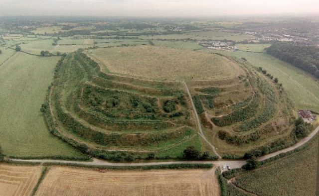
On the north-western edge of the town of Oswestry in Shropshire, a grass-covered hill rises from the surrounding plain with a regularity that is immediately recognisable as artificial. Old Oswestry — or Hen Dinas, the Old Fort, in Welsh — is one of the most elaborate and best-preserved Iron Age hillforts in Britain. Its system of ramparts, ditches, and counterscarp banks is exceptionally complex: up to seven separate circuits in places, protecting a hilltop settlement of about fifteen acres with a depth of defences that reflects centuries of construction, use, modification, and elaboration.
The hillfort sits on the border between England and Wales — a border that has shifted across this landscape repeatedly through the medieval and early modern periods, and one that the Iron Age people who built Old Oswestry would not have recognised in its modern form. The site's Welsh name, preserved in Welsh-language scholarship, is a reminder that this part of Shropshire was contested ground for much of the medieval period, and that the cultural landscape of the hillfort sits in a dual heritage of English and Welsh historical tradition.
Old Oswestry is unusual among major Iron Age hillforts in having a large town as its immediate neighbour. The modern town of Oswestry, with its medieval market character and railway history, lies immediately to the south of the fort. The juxtaposition of the prehistoric earthworks — some of the most impressive in the country — and the working town is one of the more striking contrasts in the English landscape, and one that has made Old Oswestry the subject of a long-running and still-unresolved planning controversy.
The earthworks and their development
The earthwork system at Old Oswestry was not built at one time. The earliest phases of construction probably date to the late Bronze Age or very early Iron Age, around 800–600 BC, when a relatively simple enclosure was established on the hilltop. Over the following centuries, the defences were progressively elaborated: new circuits were added outside the existing ones, the ditches were deepened, the banks were heightened, and the approaches to the main entrances were made progressively more complex.
The result is a multi-period monument of considerable archaeological complexity. The inner circuits represent the earliest phases; the outer banks and ditches are later additions, each new circuit extending the defensive system and increasing the investment of labour required to assault the fort. At the western entrance — the more elaborate of the two main approaches — the ramparts are flanked by subsidiary earthworks that create a controlled approach corridor, forcing anyone entering to pass through a succession of defended gateways. This entrance is one of the most impressive examples of Iron Age entrance architecture in Britain.
Geophysical surveys and limited excavation have provided evidence for occupation within the fort interior, including possible round house platforms and evidence for metalworking. The full extent of the interior occupation has not been systematically excavated, and the site retains a high degree of archaeological potential. The scheduled monument status and the management of the site as open access grassland have preserved the earthworks in excellent condition.
The Cornovii and the border landscape
Old Oswestry stood in the territory of the Cornovii, the Iron Age tribal grouping that occupied most of what is now Shropshire, Cheshire, and Staffordshire. The Cornovii were one of the less-documented tribes of Iron Age Britain — their territory did not coincide with the areas of Roman Britain most intensively described by classical sources, and their material culture has been less extensively studied than that of the tribes of southern England.
The Cornovii's main centre in the Roman period was Viroconium Cornoviorum — the modern Wroxeter, near Shrewsbury — which became the fourth largest Roman town in Britain. The shift from the hilltop Iron Age centres (of which Old Oswestry is the most impressive in the territory) to the valley-floor Roman town is a process that can be partially traced in the archaeological record: the abandonment of Old Oswestry in the late Iron Age or early Roman period coincides broadly with the establishment of Viroconium and the Roman pacification of the Welsh Marches.
The border character of the landscape adds a medieval dimension. Offa's Dyke — the great linear earthwork built by the Mercian king Offa in the eighth century to mark the boundary between England and Wales — passes a few miles to the west of Old Oswestry. The town of Oswestry itself was a marcher lordship, contested between English and Welsh lords through the medieval period, and the surrounding landscape carries monuments and earthworks from multiple phases of the border's turbulent history.
Threats and the conservation debate
Old Oswestry has been at the centre of a long-running conservation controversy. The hillfort's proximity to the expanding town of Oswestry has brought repeated proposals for housing development on land adjacent to and within the fort's setting. Historic England and the Council for British Archaeology have consistently opposed these proposals, arguing that the visual and archaeological setting of the fort is as important as the scheduled earthworks themselves.
The Oswestry Hillfort Heritage Initiative, a community group, has led much of the local advocacy for the fort's protection and produced detailed documentation of the threats and arguments for a wider conservation zone. Their work has raised the profile of Old Oswestry as a heritage site and brought it wider recognition as one of the most significant and most threatened Iron Age monuments in England.
The fort was included on the Historic England Heritage at Risk register. Its removal from the register in recent years reflects improved management of the site itself, though the planning pressures on its setting remain. Old Oswestry is a test case for how planning policy balances the protection of scheduled monument settings against the need for housing development in expanding market towns.
Visiting Old Oswestry
Old Oswestry is freely accessible at all times. The hillfort is managed by English Heritage and is reached by footpath from the edge of Oswestry town, a walk of about ten minutes from the nearest parking. The path climbs through the outer ramparts to the fort interior, which is open grassland with extensive views in all directions.
The earthworks are best appreciated from the exterior, where the scale and complexity of the defensive system can be seen from the surrounding fields and footpaths. Walking the outer rampart circuit — a walk of perhaps thirty minutes — gives the clearest sense of the monument's spatial organisation and the centuries of labour invested in its construction.
From the fort interior, the views extend across the Shropshire plain to the east and south, and towards the Welsh hills to the west. Offa's Dyke Path — a national trail following the line of the eighth-century earthwork — passes through the area and can be combined with a visit to Old Oswestry for a walk spanning the prehistoric and early medieval periods of the border landscape.
See the full research report for Old Oswestry, Shropshire
Scheduled monuments, PAS archaeological finds, Domesday records, geology, Roman roads, historical literature — the same report Aubrey generates for paying customers, free to read.
View full reportGet an Aubrey report for anywhere in the UK
An Aubrey Research report for Old Oswestry and the Shropshire borderland would map all PAS-recorded finds from the area, identify every scheduled monument within five kilometres — including the many Roman and medieval remains of the Marches — and cross-reference the Domesday settlements of the border parishes. Shropshire's PAS record reflects a landscape farmed and fought over since the Bronze Age. For anyone researching the Welsh Marches, Aubrey provides the full historical context for any location in the region.
Start your report