About this property
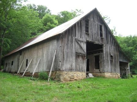
The Big Buffalo Valley Historic District, also known as the Boxley Valley Historic District, is notable as a cultural landscape in Buffalo National River. It comprises the Boxley Valley in northern Arkansas, near the town of Ponca. The valley includes a number of family-operated farms, primarily dating between 1870 and 1930. The farms are situated on either side of the road that parallels the river, Highway 43. Many of these farms are still operated by the descendants of the original homesteaders. However, of fifty residences in the valley, thirty were vacant in 1987, at the time of historic designation. The Old-Ozarks-Frontier phase, comprising the period of the 1830s to the 1870s, focusing on settlement and homesteading, with a continuing tradition of log construction extending to the 1930s. The Cosmopolitan-Ozarks phase, from circa 1895 to 1950, in which a more urban style was used for housing, with large barns and the appearance of specialized buildings for shops and services. The New-Ozarks-Frontier phase, from 1950 to the present, with a suburban design influence. The district includes Villines Mill, listed separately on the National Register of Historic Places.
Location
Categories
Property data from the National Register of Historic Places, National Park Service (public domain).
Description adapted from Wikipedia under the Creative Commons Attribution-ShareAlike 4.0 International License.
Everything a full report reveals about Big Buffalo Valley Historic District
This page lists Big Buffalo Valley Historic District. A full Aubrey report for an address near it pulls together this listing alongside battlefield records, land patents, and every other historical record within a chosen radius:
Every location is different. Not every section appears for every place, only what the historical record actually holds turns up in a report.
Questions about this property
When was Big Buffalo Valley Historic District listed on the National Register?
Big Buffalo Valley Historic District was listed on the National Register of Historic Places on July 28, 1987.
What type of historic resource is Big Buffalo Valley Historic District?
Big Buffalo Valley Historic District is classified as a district in the National Register of Historic Places.
What is the period of significance for Big Buffalo Valley Historic District?
The period of significance for Big Buffalo Valley Historic District is recorded as the civil_war era, specifically around 1870.
Can I research the history near Big Buffalo Valley Historic District?
Yes. Aubrey Research reports search National Register listings, battlefield records, land patents, and other primary historical sources within any radius of a US address. A report for an address near Big Buffalo Valley Historic District will include this listing and all other historical records in the area.
More in Newton County
Historic places, battles, and census history across Newton County.
Explore NewtonCounty ›More historic places in Arkansas
Browse all historic places in Arkansas.
View Arkansashistoric sites ›Research the history near this site
An Aubrey US report for an address near Big Buffalo Valley Historic District will include this listing alongside battlefield records and other historical sources within your chosen radius.