About this property
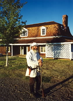
Fort Verde State Historic Park in the town of Camp Verde, Arizona is a small park that attempts to preserve parts of the Apache Wars-era fort as it appeared in the 1880s. The park was established in 1970 and was added to the National Register of Historic Places a year later. Fort Verde was established at its current location in 1871. It is significant as "the best preserved and least altered of any military post associated with General Crook’s 1872-73 campaign against the northern Apaches." Settlers in the mid-19th century near the Verde River grew corn and other crops with the prospect of getting good prices from nearby Prescott, which was the territorial capital, and from nearby miners. The rapid increase in population for the mining economy disrupted the hunting and gathering environments of the local Native American tribes, the Dilzhe'e Apache and Yavapai. In turn, they raided the farmers' crops for food. 1865, a small camp five miles (8 km) south of what is today Camp Verde. 1866–1871, Camp Lincoln, a mile north of today's Fort Verde. 1871–1873, Camp Verde, built gradually from 1871 to 1873. After approximately 1,500 local natives were placed on a reservation by 1872, the army's role changed from protecting the settlers to ensuring that the Indians stayed on the reservation. The last major military engagement with uprising natives took place in 1882 at the Battle of Big Dry Wash. The fort was never enclosed by walls or stockades, and it never saw fighting on site. At its height, it consisted of twenty-two buildings, only four of which survived until 1956, when local citizens created a small museum in the administration building. They later donated the buildings and ten acres (40,000 m2) as a State Park. Some of the buildings were built with pice, which is large adobe slabs cast within wooden frames, rather than assembled from the more familiar individual adobe bricks. == Historic structures in Fort Verde State Historic Park == The "0" Mile General Crook Trail Marker which is located in the place where in 1871 General George Crook established a military supply trail which connected Forts Whipple, Verde and Apache. The marker is located close to the Fort Verde Administration Building. The main Administration Building. It contained the main offices from which the decisions as to the operations of the fort were made. It now houses the Visitor Center of the Fort Verde Museum and contains exhibits, period artifacts from military life, and history on the Indian Scouts and Indian Wars era. Inside the Commanding officers office in the Administration Building of Fort Verde.
Location
Categories
Property data from the National Register of Historic Places, National Park Service (public domain).
Description adapted from Wikipedia under the Creative Commons Attribution-ShareAlike 4.0 International License.
Everything a full report reveals about Fort Verde District
This page lists Fort Verde District. A full Aubrey report for an address near it pulls together this listing alongside battlefield records, land patents, and every other historical record within a chosen radius:
Every location is different. Not every section appears for every place, only what the historical record actually holds turns up in a report.
Nearby Battles
Questions about this property
When was Fort Verde District listed on the National Register?
Fort Verde District was listed on the National Register of Historic Places on October 6, 1971.
What type of historic resource is Fort Verde District?
Fort Verde District is classified as a district in the National Register of Historic Places.
What is the period of significance for Fort Verde District?
The period of significance for Fort Verde District is recorded as the modern era, specifically around 1970.
Can I research the history near Fort Verde District?
Yes. Aubrey Research reports search National Register listings, battlefield records, land patents, and other primary historical sources within any radius of a US address. A report for an address near Fort Verde District will include this listing and all other historical records in the area.
More in Yavapai County
Historic places, battles, and census history across Yavapai County.
Explore YavapaiCounty ›Research the history near this site
An Aubrey US report for an address near Fort Verde District will include this listing alongside battlefield records and other historical sources within your chosen radius.