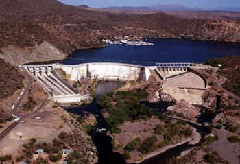
Stewart Mountain Dam
National Register of Historic Places

Stewart Mountain Dam

Phoenix, Maricopa County, Arizona
Listed
August 7, 2017
Type
Structure
Period
Industrial
Ref No.
100001411

About this property

The Stewart Mountain Dam is a concrete thin arch dam located 41 miles northeast of Phoenix, Arizona. The dam is 1,260 feet (380 m) long, 207 feet (63 m) high, and was built between 1928 and 1930. The dam includes a 13,000 kilowatt (kW) hydroelectric generating unit that is operated by SRP (Salt River Project), an Arizona public utility. It is primarily operated during the summer months. The dam forms Saguaro Lake as it slows the passage of the Salt River in Maricopa County, Arizona. It was named after a ranch that used to be located nearby known as the Old Stewart Ranch. A camp was built just below the dam in 1927 to house the construction workers; after the damn's completion it was turned into the Saguaro Lake Guest Ranch. The dam was listed on the National Register of Historic Places in 2017.

Location

Phoenix, Maricopa County, Arizona
33.56661, -111.53611

Categories

POLITICS/GOVERNMENTENGINEERINGCOMMUNITY PLANNING AND DEVELOPMENT
Sources

Property data from the National Register of Historic Places, National Park Service (public domain).

Description adapted from Wikipedia under the Creative Commons Attribution-ShareAlike 4.0 International License.

Unlimited access

Everything a full report reveals about Stewart Mountain Dam

This page lists Stewart Mountain Dam. A full Aubrey report for an address near it pulls together this listing alongside battlefield records, land patents, and every other historical record within a chosen radius:

Overview
An interactive map of the location with historic sites, battles and Native heritage plotted, and its full story era by era.
The Land
The historic sites and place names around the location, and how this land was settled and used.
Geology
The bedrock beneath the site, its age and rock type, reaching back millions of years.
LiDAR Terrain
Laser-scanned terrain that reveals earthworks and old features hidden in the landscape.
Conflict & War
The battles, raids and skirmishes fought near here, across every era of American conflict.
The Civil War
The Civil War on this ground, 1861 to 1865: who held it, and the battles, camps and regiments nearby.
The Soldiers
The men who marched from here in the Civil War, named and traced where the record allows.
Native Heritage
The Native nations who held this land, mapped across time from before European contact to today.
Settlement
Who claimed and held this ground, from Indigenous homelands through the colonial powers to the United States.
The Community
How the town grew, who came, and what kind of place it became, traced through the census record.
Rivers & Rail
The rivers, canals and railroads that connected this place between 1830 and 1911.
Notable People
The people born, buried or genuinely tied to this exact place, with their stories.
Historical Maps
Historic maps of the location layered over how it looks today.
Finds & Access
Museum objects tied to the area, and the laws on searching, collecting and access here.
Literature
The old books, county histories and archives that mention this place, quoted with their sources.
Spotlight
A deep dive into the most remarkable, lesser-known history of the place, traced back to the record.
Points of Interest
The most significant historic sites and landmarks near the location, and why they matter.
Timeline
The whole story of the location told era by era, from first peoples to the present day.
First month just $5.99, then $11.99 a month. Unlimited locations, cancel anytime.

Every location is different. Not every section appears for every place, only what the historical record actually holds turns up in a report.

Start your Stewart Mountain Dam report
Or see a real report first

Nearby Historic Sites

Mormon Flat Dam
Industrial
5.4 mi
Mormon Flat Bridge
Industrial
5.7 mi
Boulder Creek Bridge
Industrial
6.9 mi
Fort McDowell
Early Republic
9.6 mi
Horse Mesa Dam
Industrial
11.2 mi

Nearby Battles

Skeleton Cave Massacre (Salt River Cave) (December 28, 1872)
1872Indian Wars
4 mi

Questions about this property

When was Stewart Mountain Dam listed on the National Register?

Stewart Mountain Dam was listed on the National Register of Historic Places on August 7, 2017.

What type of historic resource is Stewart Mountain Dam?

Stewart Mountain Dam is classified as a structure in the National Register of Historic Places.

What is the period of significance for Stewart Mountain Dam?

The period of significance for Stewart Mountain Dam is recorded as the industrial era, specifically around 1928.

Can I research the history near Stewart Mountain Dam?

Yes. Aubrey Research reports search National Register listings, battlefield records, land patents, and other primary historical sources within any radius of a US address. A report for an address near Stewart Mountain Dam will include this listing and all other historical records in the area.

More in Maricopa County

Historic places, battles, and census history across Maricopa County.

Explore MaricopaCounty ›

More historic places in Arizona

Browse all historic places in Arizona.

View Arizonahistoric sites ›

Conflict records

Explore 19,000+ military engagements across American history.

Browse US conflicts ›

Arizona history

Colonial settlement, territorial period, and statehood narrative.

Arizonahistory ›

Research the history near this site

An Aubrey US report for an address near Stewart Mountain Dam will include this listing alongside battlefield records and other historical sources within your chosen radius.

Research your locationView a free sample report