About this property
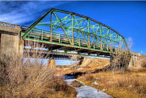
The Black Squirrel Creek Bridge carries U.S. 24 over Black Squirrel Creek in El Paso County, Colorado. Prior to 2012, it was locally known as the "green bridge" or "old green bridge"—a historic single-span, Parker through truss bridge that was completed in 1935 and listed on the National Register of Historic Places in 2002. Because it no longer met highway safety standards, the bridge was dismantled and replaced by a newer span in 2012. In the 1930s, the road in El Paso County (which would become U.S. 24) underwent major reconstruction, including the addition of several new bridges. The bridge at Black Squirrel Creek was contracted to Charles B. Owen and A. S. Horner. The truss was built by the Minneapolis-Moline Power Implement Company, and construction of the bridge was complete in 1935. The bridge's concrete abutments are hollow, each with a pair of barred "windows". According to a bridge foreman for El Paso County, the "windows" allowed the removal of formwork once they cured, and the bars were put in place to keep people out. However, the barred "windows" led to tales of uncertain authenticity that a chain gang or German prisoners of World War II were locked up in the abutments, which resemble prison cells. The bridge was nominated for inclusion on the National Register of Historic Places for its significance in transportation and engineering under Criteria A and C, respectively. At the time of its nomination in 2002, the Black Squirrel Creek Bridge was one of eight Parker through trusses to survive in use on Colorado's highways. The bridge was listed on the National Register on October 15, 2002. In 2008, twelve state-owned bridges in the county, including the Black Squirrel Creek Bridge, were rated in "poor" condition for failing to meet modern safety standards. The shoulders were only 2 feet (0.61 m) wide and the vertical clearance of 15 feet (4.6 m) was 9 inches (23 cm) short of the then-current minimum, making the bridge potentially hazardous. As part of CDOT's Adopt-A-Bridge program, the agency would have dismantled the bridge and given it to a group willing to take the structure, for such purpose as a pedestrian or bicycle route. A county engineer said of the bridge in 2011 that "we have no use for a structure like that — it's obsolete... All you could do is some type of display, and the cost doesn't seem to justify the benefit." Since no one took the offer of the bridge, a replacement project began in November 2011, estimated to last about one year. A two-lane paved detour bridge was first built to bypass the bridge. Traffic continued to flow on the bridge until the detour opened in January 2012. Crews then proceeded to remove the old span, build its replacement, repave, build new guardrails, and add seed and mulch. The project finished in August 2012 at a cost of about $3.5 million. The new bridge has a low profile, and the design incorporated the 1934 plaque from the original structure.
Location
Categories
Property data from the National Register of Historic Places, National Park Service (public domain).
Description adapted from Wikipedia under the Creative Commons Attribution-ShareAlike 4.0 International License.
Everything a full report reveals about Black Squirrel Creek Bridge
This page lists Black Squirrel Creek Bridge. A full Aubrey report for an address near it pulls together this listing alongside battlefield records, land patents, and every other historical record within a chosen radius:
Every location is different. Not every section appears for every place, only what the historical record actually holds turns up in a report.
Questions about this property
When was Black Squirrel Creek Bridge listed on the National Register?
Black Squirrel Creek Bridge was listed on the National Register of Historic Places on October 14, 2002.
What type of historic resource is Black Squirrel Creek Bridge?
Black Squirrel Creek Bridge is classified as a structure in the National Register of Historic Places.
What is the period of significance for Black Squirrel Creek Bridge?
The period of significance for Black Squirrel Creek Bridge is recorded as the industrial era, specifically around 1935.
Can I research the history near Black Squirrel Creek Bridge?
Yes. Aubrey Research reports search National Register listings, battlefield records, land patents, and other primary historical sources within any radius of a US address. A report for an address near Black Squirrel Creek Bridge will include this listing and all other historical records in the area.
More in El Paso County
Historic places, battles, and census history across El Paso County.
Explore El PasoCounty ›More historic places in Colorado
Browse all historic places in Colorado.
View Coloradohistoric sites ›Research the history near this site
An Aubrey US report for an address near Black Squirrel Creek Bridge will include this listing alongside battlefield records and other historical sources within your chosen radius.