About this property
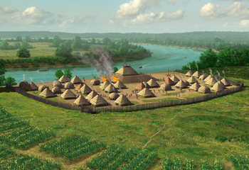
The Annis Mound and Village site (15BT2, 15BT20, and 15BT21) is an American prehistoric Middle Mississippian culture archaeological site located on the bank of the Green River in Butler County, Kentucky, several miles northwest of Morgantown in the Big Bend region. It was occupied from about 800 CE to about 1300 CE. The site consisted of a platform mound (15 BT 2) measuring 33.5 metres (110 ft) square by 3.7 metres (12 ft) in height with special use structures at its summit. It was surrounded by the village area (15 BT 20) which was situated north of the generally east to west course of the Green River at the sites location. The village featured domestic structures and several sequential iterations of an encircling defensive palisade of upright tree trunks. The palisade was built three different times in the site's history; each one larger than its predecessor and encircling an expanded village area. A bastion was discovered in the northwest corner of the last version of the palisade. Agriculture was based on the cultivation of maize as a staple of the diet. Ceramics found at the site were typical Mississippian culture pottery; although a few sherds of high status pottery from the Cahokia site were discovered during excavations of the platform mound summit structure. The site also features a 1 metre (3.3 ft) in height 30 metres (98 ft) by 35 metres (115 ft) circular feature known as the Annis Sand Mound (15 BT 21) that dates from the Archaic period. This feature lies directly north of the village area and outside of the area encompassed by the palisade. A 9 acres (3.6 ha) area at the site was listed on the National Register of Historic Places as "Annis Mound and Village Site" in 1985.
Location
Categories
Property data from the National Register of Historic Places, National Park Service (public domain).
Description adapted from Wikipedia under the Creative Commons Attribution-ShareAlike 4.0 International License.
Everything a full report reveals about Annis Mound and Village Site (15BT2; 15BT20; 15BT21)
This page lists Annis Mound and Village Site (15BT2; 15BT20; 15BT21). A full Aubrey report for an address near it pulls together this listing alongside battlefield records, land patents, and every other historical record within a chosen radius:
Every location is different. Not every section appears for every place, only what the historical record actually holds turns up in a report.
Questions about this property
When was Annis Mound and Village Site (15BT2; 15BT20; 15BT21) listed on the National Register?
Annis Mound and Village Site (15BT2; 15BT20; 15BT21) was listed on the National Register of Historic Places on December 21, 1985.
What type of historic resource is Annis Mound and Village Site (15BT2; 15BT20; 15BT21)?
Annis Mound and Village Site (15BT2; 15BT20; 15BT21) is classified as a site in the National Register of Historic Places.
What is the period of significance for Annis Mound and Village Site (15BT2; 15BT20; 15BT21)?
The period of significance for Annis Mound and Village Site (15BT2; 15BT20; 15BT21) is recorded as the pre_contact era, specifically around 1300.
Can I research the history near Annis Mound and Village Site (15BT2; 15BT20; 15BT21)?
Yes. Aubrey Research reports search National Register listings, battlefield records, land patents, and other primary historical sources within any radius of a US address. A report for an address near Annis Mound and Village Site (15BT2; 15BT20; 15BT21) will include this listing and all other historical records in the area.
More in Butler County
Historic places, battles, and census history across Butler County.
Explore ButlerCounty ›More historic places in Kentucky
Browse all historic places in Kentucky.
View Kentuckyhistoric sites ›Research the history near this site
An Aubrey US report for an address near Annis Mound and Village Site (15BT2; 15BT20; 15BT21) will include this listing alongside battlefield records and other historical sources within your chosen radius.