About this property
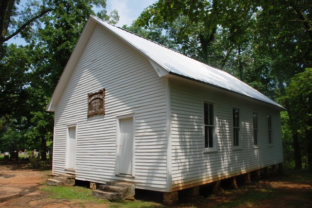
Mammoth Cave Baptist Church and Cemetery is a historic church in Mammoth Cave National Park in Kentucky. It was built in 1827 and added to the National Register of Historic Places in 1991. The church was established in 1827. The current building was built in 1927 after the original was destroyed in a tornado. It is a 42 by 26 feet (12.8 m × 7.9 m) one-story gable-front frame building, on a foundation of stacked sandstone blocks. Floyd Collins (1887–1925), cave explorer and famous cave accident victim Good Spring Baptist Church and Cemetery: also in Mammoth Cave National Park Joppa Baptist Church and Cemetery: also in Mammoth Cave National Park National Register of Historic Places listings in Edmonson County, Kentucky National Register of Historic Places listings in Mammoth Cave National Park Mammoth Cave Baptist Church and Cemetery at Find a Grave U.S. Geological Survey Geographic Names Information System: Mammoth Cave Baptist Church U.S. Geological Survey Geographic Names Information System: Mammoth Cave Cemetery
Location
Categories
Property data from the National Register of Historic Places, National Park Service (public domain).
Description adapted from Wikipedia under the Creative Commons Attribution-ShareAlike 4.0 International License.
Everything a full report reveals about Mammoth Cave Baptist Church and Cemetery
This page lists Mammoth Cave Baptist Church and Cemetery. A full Aubrey report for an address near it pulls together this listing alongside battlefield records, land patents, and every other historical record within a chosen radius:
Every location is different. Not every section appears for every place, only what the historical record actually holds turns up in a report.
Questions about this property
When was Mammoth Cave Baptist Church and Cemetery listed on the National Register?
Mammoth Cave Baptist Church and Cemetery was listed on the National Register of Historic Places on May 7, 1991.
What type of historic resource is Mammoth Cave Baptist Church and Cemetery?
Mammoth Cave Baptist Church and Cemetery is classified as a district in the National Register of Historic Places.
What is the period of significance for Mammoth Cave Baptist Church and Cemetery?
The period of significance for Mammoth Cave Baptist Church and Cemetery is recorded as the early_republic era, specifically around 1827.
Can I research the history near Mammoth Cave Baptist Church and Cemetery?
Yes. Aubrey Research reports search National Register listings, battlefield records, land patents, and other primary historical sources within any radius of a US address. A report for an address near Mammoth Cave Baptist Church and Cemetery will include this listing and all other historical records in the area.
More in Edmonson County
Historic places, battles, and census history across Edmonson County.
Explore EdmonsonCounty ›More historic places in Kentucky
Browse all historic places in Kentucky.
View Kentuckyhistoric sites ›Research the history near this site
An Aubrey US report for an address near Mammoth Cave Baptist Church and Cemetery will include this listing alongside battlefield records and other historical sources within your chosen radius.