About this property
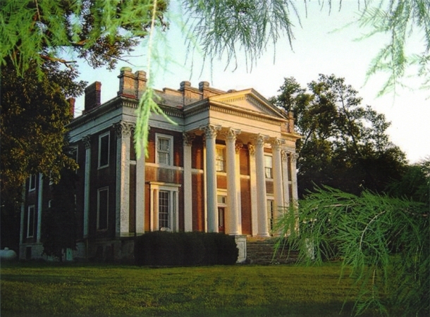
Ward Hall is a Greek Revival antebellum plantation mansion located in Georgetown, Kentucky. The main house covers 12,000 square feet (1,100 m2), with 27-foot (8.2 m) high Corinthian fluted columns. The mansion was built for planter Junius Richard Ward (1802–1883) and his wife Matilda (Viley) Ward circa 1857 on their 500-acre plantation in Scott County, Kentucky, in the Bluegrass Region. Matilda Viley was the sister of Capt. Willa Viley, a pioneer thoroughbred breeder of Scott County. He was first president of the Lexington Racing Association. Junius Ward was a grandson of the Col. Robert and Jemima (Suggett) Johnson family of Scott County, Kentucky. This was an extraordinarily powerful political and economic family dynasty, whose members extended their influence by developing cotton plantations throughout the Mississippi Delta. Like Ward, many members had plantations in Washington County along the Mississippi River near Greenville, Mississippi. One of Ward's cousins, Lycurgus Johnson, owned Lakeport Plantation on the other side of the river near Lake Village, Arkansas. Many of these family members had plantation houses in the deep South and summer residences and plantations in Scott County, Kentucky. The Wards had this Scott County mansion built as a summer residence. Their Kentucky plantation cultivated tobacco and hemp, and raised award-winning livestock, including racehorses. The Wards also owned a large cotton plantation near Leota Landing, Washington County, Mississippi, where they wintered. Their plantation house in Mississippi served as their winter residence. Due to financial reverses following the Civil War, Junius Ward declared bankruptcy; he was forced to sell the Scott County plantation in 1869. Nearby planters bought the property in two lots. A later owner offered the property with the mansion to the Commonwealth of Kentucky, with the condition that it be used as the state capitol. The state declined. The mansion design is attributed to Major Thomas Lewinski. It is the embodiment of numerous Minard Lafever design elements from his 1829 and 1835 pattern books. It was built by Taylor Buffington, with the assistance of James Bailey, a free man of color. It measures 62 ft wide (19 m) and 69 ft long (21 m), four stories, with a 14-foot-wide (4.3 m), 65-foot-long (20 m) central corridor on three floors. There are three rooms on each side of the central corridor, with the exception of the area set aside for the nautilus-chambered double elliptical staircase which rises three floors. The floor plan is based on #17/18 of the 20 permutations within the Palladian grammar by Andrea Palladio, an influential 16th-century Italian architect. At each end of the central corridor on the main floor are front and rear entrances with cut-glass transom and side lights. The domestic servants' cooking area and sleeping rooms in the basement represent one of the most intact antebellum basements in the country. In that period, the servants were enslaved African Americans. Slaves also served as laborers and artisans on the plantation: working with livestock and in the fields.
Location
Categories
Property data from the National Register of Historic Places, National Park Service (public domain).
Description adapted from Wikipedia under the Creative Commons Attribution-ShareAlike 4.0 International License.
Everything a full report reveals about Ward Hall
This page lists Ward Hall. A full Aubrey report for an address near it pulls together this listing alongside battlefield records, land patents, and every other historical record within a chosen radius:
Every location is different. Not every section appears for every place, only what the historical record actually holds turns up in a report.
Questions about this property
When was Ward Hall listed on the National Register?
Ward Hall was listed on the National Register of Historic Places on April 1, 1973.
What type of historic resource is Ward Hall?
Ward Hall is classified as a building in the National Register of Historic Places.
What is the period of significance for Ward Hall?
The period of significance for Ward Hall is recorded as the early_republic era.
Can I research the history near Ward Hall?
Yes. Aubrey Research reports search National Register listings, battlefield records, land patents, and other primary historical sources within any radius of a US address. A report for an address near Ward Hall will include this listing and all other historical records in the area.
More in Scott County
Historic places, battles, and census history across Scott County.
Explore ScottCounty ›More historic places in Kentucky
Browse all historic places in Kentucky.
View Kentuckyhistoric sites ›Research the history near this site
An Aubrey US report for an address near Ward Hall will include this listing alongside battlefield records and other historical sources within your chosen radius.