About this property
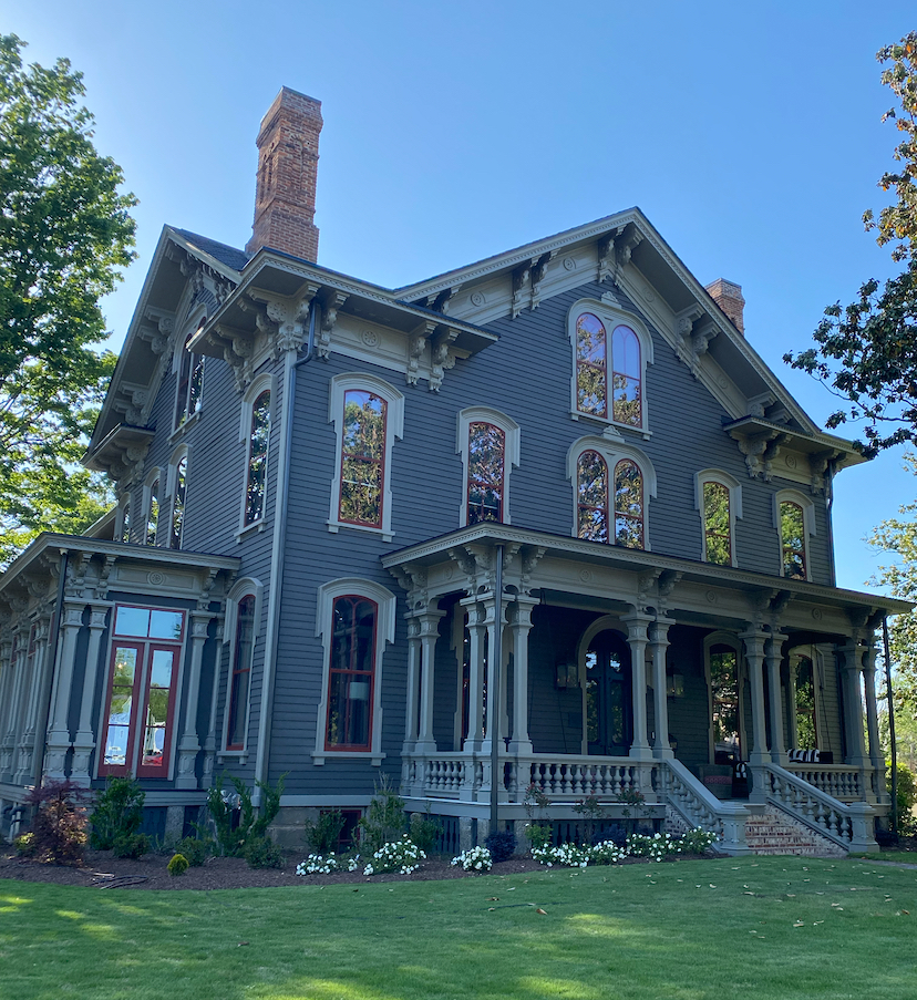
The Andrews-Duncan House is a historic house located at 407 North Blount Street in Raleigh, North Carolina, United States. Built in 1874 for a prominent businessman, the Italianate style home was designed by architect George S. H. Appleget. The house was added to the National Register of Historic Places (NRHP) in 1972 and is currently owned by the state government. A large tree named after a presidential candidate once stood behind the house and is commemorated with a historical marker. In April 1873, Alexander Boyd Andrews (1841–1915), a railroad executive and former Confederate captain in the 1st North Carolina Cavalry Regiment, bought a parcel of land from businessman Richard Stanhope Pullen of Pullen Plantation. The lot was located on the northwest corner of Blount and North Streets in downtown Raleigh. Andrews chose architect George S. H. Appleget to design his Victorian home. Appleget's designs in Raleigh include Estey Hall on the campus of Shaw University and the Heck-Andrews House, located next door to the Andrews-Duncan House. His most well known public building design is the Cabarrus County Courthouse in Concord. Andrews continued living in the home until his death in 1915. On October 1, 1919, the Andrews estate sold the home to Laura Duncan Pearson, the wife of a local dentist and widow of a tobacco industrialist. Ownership of the home remained in the Duncan family until at least the 1970s when the historical survey of the property was completed. The building used to serve as offices for North Carolina state government workers until 2007. It fell into disrepair under state ownership until early 2017 when it was bought by Tina Konidaris and Jeff Turpin. After extensive repairs their family moved into the house in 2023. Since then, it has become a private residence and has won multiple awards for historic preservation. The house was added to the NRHP on January 20, 1972, and declared a Raleigh Historic Landmark on November 6, 1972. A historical marker in front of the building states: "Alexander B. Andrews/1841-1915/Railroad builder and financier. Vice-president, Southern Railroad; superintendent, North Carolina Railroad. Home is here." A large white oak tree, nicknamed the "Henry Clay Oak", previously stood behind the home on the southwest corner of the property. It measured approximately 100 feet (30 m) tall with a 100-foot spread and was estimated to be anywhere from 200 to 350 years old. The tree was famous for supposedly being the site where in 1844 politician Henry Clay wrote his letter opposing the annexation of Texas. The publication of that letter was one of the main reasons he lost the 1844 presidential election. Due to weather damage and a deadly root fungus, the tree was felled in October 1991. Two historical markers in front of where the tree once stood state: "Henry Clay Oak/Henry Clay, on a visit to this city, wrote the famous Raleigh Letter, April 17, 1844, opposing the annexation of Texas. Many authorities believe that this statement cost him the presidential election of 1844. According to tradition Clay wrote the letter while sitting under this oak tree, in the yard of Colonel William Polk, at whose home he was a guest./Erected by Colonel Polk Chapter/D.A.R./1939" and "Raleigh/Historic Property/The Henry Clay Oak/Circa 1650"
Location
Categories
Property data from the National Register of Historic Places, National Park Service (public domain).
Description adapted from Wikipedia under the Creative Commons Attribution-ShareAlike 4.0 International License.
Everything a full report reveals about Andrews-Duncan House
This page lists Andrews-Duncan House. A full Aubrey report for an address near it pulls together this listing alongside battlefield records, land patents, and every other historical record within a chosen radius:
Every location is different. Not every section appears for every place, only what the historical record actually holds turns up in a report.
Questions about this property
When was Andrews-Duncan House listed on the National Register?
Andrews-Duncan House was listed on the National Register of Historic Places on January 20, 1972.
What type of historic resource is Andrews-Duncan House?
Andrews-Duncan House is classified as a building in the National Register of Historic Places.
What is the period of significance for Andrews-Duncan House?
The period of significance for Andrews-Duncan House is recorded as the civil_war era, specifically around 1874.
Can I research the history near Andrews-Duncan House?
Yes. Aubrey Research reports search National Register listings, battlefield records, land patents, and other primary historical sources within any radius of a US address. A report for an address near Andrews-Duncan House will include this listing and all other historical records in the area.
More in Wake County
Historic places, battles, and census history across Wake County.
Explore WakeCounty ›More historic places in North Carolina
Browse all historic places in North Carolina.
View North Carolinahistoric sites ›North Carolina history
Colonial settlement, territorial period, and statehood narrative.
North Carolinahistory ›Research the history near this site
An Aubrey US report for an address near Andrews-Duncan House will include this listing alongside battlefield records and other historical sources within your chosen radius.