About this property
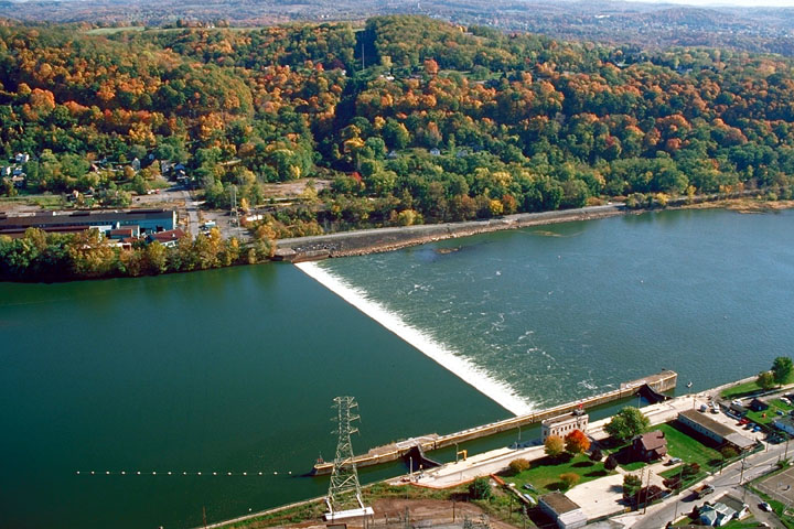
The Allegheny River Lock and Dam No. 4 in Harrison Township, Allegheny County, Pennsylvania, is a lock that was built 1920-1927, and opened in 1927, 24.2 miles upstream from the mouth of the river in Pittsburgh. The lock and dam were built by the U.S. Army Corps of Engineers as a part of an extensive system of locks and dams to improve navigation along the Allegheny River. It is located about 24.2 Miles up the Allegheny River from the Point in Downtown Pittsburgh. Also, it is about 6 Miles down the Allegheny from the mouth of the Kiskiminetas River. Upriver, Allegheny Pool No. 4 has an average water elevation of 745.4 feet above sea level and extends about 6.2 miles upriver to Allegheny River Lock and Dam No. 5. Downriver, Allegheny Pool No. 3 has an average water elevation of 734.5 feet above sea level and extends about 9.7 miles downriver to Allegheny River Lock and Dam No. 3. Thus Lock No. 4 lifts and lowers boats about 10.9 feet between the pools. It has a single lock and a fixed-crest dam, keeping the river depth at least 9 feet in the pool above the dam. The amount of water that flows over the dam is not controlled locally, so it does not provide flood control, but it does help provide water to municipalities. Traffic through the lock was about 1.8 million tons in 1998, including shipments of coal, petroleum, sand and gravel, ore, steel, chemicals, fertilizer, salt, flour, lime, and slag. It was listed on the National Register of Historic Places on April 21, 2000.
Location
Categories
Property data from the National Register of Historic Places, National Park Service (public domain).
Description adapted from Wikipedia under the Creative Commons Attribution-ShareAlike 4.0 International License.
Everything a full report reveals about Allegheny River Lock and Dam No. 4
This page lists Allegheny River Lock and Dam No. 4. A full Aubrey report for an address near it pulls together this listing alongside battlefield records, land patents, and every other historical record within a chosen radius:
Every location is different. Not every section appears for every place, only what the historical record actually holds turns up in a report.
Nearby Battles
Questions about this property
When was Allegheny River Lock and Dam No. 4 listed on the National Register?
Allegheny River Lock and Dam No. 4 was listed on the National Register of Historic Places on April 20, 2000.
What type of historic resource is Allegheny River Lock and Dam No. 4?
Allegheny River Lock and Dam No. 4 is classified as a structure in the National Register of Historic Places.
What is the period of significance for Allegheny River Lock and Dam No. 4?
The period of significance for Allegheny River Lock and Dam No. 4 is recorded as the civil_war era.
Can I research the history near Allegheny River Lock and Dam No. 4?
Yes. Aubrey Research reports search National Register listings, battlefield records, land patents, and other primary historical sources within any radius of a US address. A report for an address near Allegheny River Lock and Dam No. 4 will include this listing and all other historical records in the area.
More in Allegheny County
Historic places, battles, and census history across Allegheny County.
Explore AlleghenyCounty ›More historic places in Pennsylvania
Browse all historic places in Pennsylvania.
View Pennsylvaniahistoric sites ›Pennsylvania history
Colonial settlement, territorial period, and statehood narrative.
Pennsylvaniahistory ›Research the history near this site
An Aubrey US report for an address near Allegheny River Lock and Dam No. 4 will include this listing alongside battlefield records and other historical sources within your chosen radius.