About this property
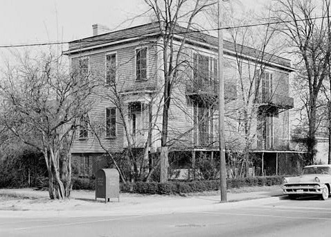
Columbia Historic District II is a national historic district located at Columbia, South Carolina. The district encompasses 113 contributing buildings and 1 contributing site in a former residential section of Columbia. They were built between the early-19th century and the 1930s (majority between 1900 and 1918) and are now mostly used for commercial purposes. The buildings are in the Greek Revival, Gothic Revival, Classical Revival, and the “Columbia Cottage” styles. Notable buildings include the Robert Mills House, Debruhl-Marshall House, Hampton-Preston House, Episcopal Church of the Good Shepherd, Crawford-Clarkson House, Maxcy Gregg House, Hale-Elmore-Seibels House, St.
Location
Federal Designation
The National Register of Historic Places, administered by the National Park Service, is the United States federal government's official list of districts, sites, buildings, structures, and objects deemed worthy of preservation for their historical, architectural, archaeological, engineering, or cultural significance. Listing on the National Register recognizes a property's importance to American history but does not place restrictions on private owners; it does, however, make properties eligible for federal historic preservation tax incentives and enables consideration in federal planning decisions. This property is recorded in the National Register under reference number 100003002. It was listed on October 2, 2018.
Categories
Property data from the National Register of Historic Places, National Park Service (public domain).
Description adapted from Wikipedia under the Creative Commons Attribution-ShareAlike 4.0 International License.
Questions about this property
When was Columbia Historic District II (Boundary Increase II and Boundary Decrease) listed on the National Register?
Columbia Historic District II (Boundary Increase II and Boundary Decrease) was listed on the National Register of Historic Places on October 2, 2018.
What type of historic resource is Columbia Historic District II (Boundary Increase II and Boundary Decrease)?
Columbia Historic District II (Boundary Increase II and Boundary Decrease) is classified as a district in the National Register of Historic Places.
What is the period of significance for Columbia Historic District II (Boundary Increase II and Boundary Decrease)?
The period of significance for Columbia Historic District II (Boundary Increase II and Boundary Decrease) is recorded as the civil_war era.
Can I research the history near Columbia Historic District II (Boundary Increase II and Boundary Decrease)?
Yes. Aubrey Research reports search National Register listings, battlefield records, land patents, and other primary historical sources within any radius of a US address. A report for an address near Columbia Historic District II (Boundary Increase II and Boundary Decrease) will include this listing and all other historical records in the area.
More historic places in South Carolina
Browse all historic places in South Carolina.
View South Carolinahistoric sites ›South Carolina history
Colonial settlement, territorial period, and statehood narrative.
South Carolinahistory ›Research the history near this site
An Aubrey US report for an address near Columbia Historic District II (Boundary Increase II and Boundary Decrease) will include this listing alongside battlefield records and other historical sources within your chosen radius.