About this property
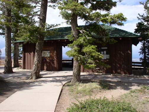
The Rainbow Point Comfort Station and Overlook Shelter in Bryce Canyon National Park, Utah were designed in 1939 by A.V. Jory of the National Park Service Branch of Plans and Designs in the National Park Service Rustic style. Located at the southern end of the Rim Road at Rainbow Point, the buildings were built by the Civilian Conservation Corps in 1940. The "comfort station", otherwise known as a public toilet, is set back from the rim of Bryce Canyon. The comfort station is designed in the "logs-out" style, sheathed in V-joint wood shiplap siding, with half-round logs covering the joints. The roof is framed with log rafters. The shelter is located directly on the edge of the canyon, facing outwards. The shelter uses massive vertical log posts supporting a log-framed roof. Vertical board siding is used as an infill on the rear half, which is open to the canyon on the front. Siding encloses two small storage areas behind the main interpretive displays.
Location
Categories
Property data from the National Register of Historic Places, National Park Service (public domain).
Description adapted from Wikipedia under the Creative Commons Attribution-ShareAlike 4.0 International License.
Everything a full report reveals about Rainbow Point Comfort Station and Overlook Shelter
This page lists Rainbow Point Comfort Station and Overlook Shelter. A full Aubrey report for an address near it pulls together this listing alongside battlefield records, land patents, and every other historical record within a chosen radius:
Every location is different. Not every section appears for every place, only what the historical record actually holds turns up in a report.
Questions about this property
When was Rainbow Point Comfort Station and Overlook Shelter listed on the National Register?
Rainbow Point Comfort Station and Overlook Shelter was listed on the National Register of Historic Places on April 24, 1995.
What type of historic resource is Rainbow Point Comfort Station and Overlook Shelter?
Rainbow Point Comfort Station and Overlook Shelter is classified as a building in the National Register of Historic Places.
What is the period of significance for Rainbow Point Comfort Station and Overlook Shelter?
The period of significance for Rainbow Point Comfort Station and Overlook Shelter is recorded as the industrial era, specifically around 1939.
Can I research the history near Rainbow Point Comfort Station and Overlook Shelter?
Yes. Aubrey Research reports search National Register listings, battlefield records, land patents, and other primary historical sources within any radius of a US address. A report for an address near Rainbow Point Comfort Station and Overlook Shelter will include this listing and all other historical records in the area.
More in Garfield County
Historic places, battles, and census history across Garfield County.
Explore GarfieldCounty ›Research the history near this site
An Aubrey US report for an address near Rainbow Point Comfort Station and Overlook Shelter will include this listing alongside battlefield records and other historical sources within your chosen radius.