About this property
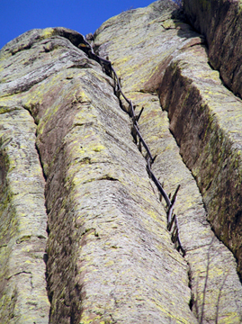
The Ladder at Devils Tower was first constructed and used in 1893 by William Rogers and Willard Ripley to publicly ascend Devil's Tower. Two years later Roger's wife Linnie ascended the tower via the ladder, one of a total of about 215 who have used the ladder. The last use was by Babe "The Human Fly" White in 1927. The present tower ladder consists of a series of wooden stakes connected on the outside by vertical wood planks. One end of each stake is driven sideways into a rock crevice, vertically ascending the southeast side of the tower. Attached with nails and/or baling wire to the other end of the stakes are 12-inch (300 mm) lengths of one-by-four-inch (25 mm × 100 mm) lumber. The ladder ascends from about 100 feet (30 m) above the ground to the summit, and is about 170 feet (50 m) long. Because of its small scale in comparison to the tower, it is very difficult to see in modern photographs, and visitors to the tower usually must view it through a telescope. The lowest 100 feet (30 m) were removed in the 1930s as a safety measure. The remaining ladder was restored in 1972.
Location
Categories
Property data from the National Register of Historic Places, National Park Service (public domain).
Description adapted from Wikipedia under the Creative Commons Attribution-ShareAlike 4.0 International License.
Everything a full report reveals about Tower Ladder-Devils Tower National Monument
This page lists Tower Ladder-Devils Tower National Monument. A full Aubrey report for an address near it pulls together this listing alongside battlefield records, land patents, and every other historical record within a chosen radius:
Every location is different. Not every section appears for every place, only what the historical record actually holds turns up in a report.
Questions about this property
When was Tower Ladder-Devils Tower National Monument listed on the National Register?
Tower Ladder-Devils Tower National Monument was listed on the National Register of Historic Places on July 23, 2000.
What type of historic resource is Tower Ladder-Devils Tower National Monument?
Tower Ladder-Devils Tower National Monument is classified as a structure in the National Register of Historic Places.
What is the period of significance for Tower Ladder-Devils Tower National Monument?
The period of significance for Tower Ladder-Devils Tower National Monument is recorded as the civil_war era.
Can I research the history near Tower Ladder-Devils Tower National Monument?
Yes. Aubrey Research reports search National Register listings, battlefield records, land patents, and other primary historical sources within any radius of a US address. A report for an address near Tower Ladder-Devils Tower National Monument will include this listing and all other historical records in the area.
More in Crook County
Historic places, battles, and census history across Crook County.
Explore CrookCounty ›Research the history near this site
An Aubrey US report for an address near Tower Ladder-Devils Tower National Monument will include this listing alongside battlefield records and other historical sources within your chosen radius.