David Robertson / Wikimedia Commons / CC BY-SA 2.0
History & Significance
North Norfolk's countryside north-west of Fakenham conceals, in a field beside a private farm track, one of England's most eloquent abandoned settlements. Godwick was a medieval village of perhaps ten to twenty households, served by a church, organised around a green, and farming the heavy clay soils of central Norfolk from at least the eleventh century. By 1600 it was empty. The earthworks of its houses, lanes, and closes survive in a pasture field; a ruined seventeenth-century barn rises from the site of the former village; and a tree-grown mound nearby marks the moated site of the manor house. Godwick is the most accessible and evocative of Norfolk's many lost villages.
The Domesday Book of 1086 records Godwick as a small but functioning settlement. Its population was modest — fewer than twenty named individuals in the survey — and it was held by a Norman lord who had displaced English predecessors after the Conquest. Through the twelfth and thirteenth centuries, Godwick grew slowly, its church built or rebuilt in stone, its open fields supporting a mixed arable and pastoral economy typical of north Norfolk. The fourteenth century brought the Black Death, which cut the population of many Norfolk settlements by a third to a half; Godwick shrank but survived.
The abandonment came in the late fifteenth and early sixteenth centuries, driven by the economics of the wool trade. Converting arable land to sheep pasture required far fewer labourers than mixed farming, and landlords across England depressed or evicted village populations to make way for flocks. In Norfolk, this process was particularly intense, and dozens of villages — among them Godwick — simply emptied.
What survives at Godwick
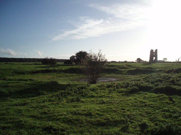
The earthworks at Godwick are among the best-preserved of any English deserted medieval village. Walking across the pasture field, a careful eye can distinguish the humps and hollows that mark the platforms where houses once stood — slightly raised, rectangular platforms separated by shallow ditches that were once the lanes between properties. The village plan can be traced in outline: a rough north-south arrangement of house plots, with what was probably a green or open space at the centre, and the site of the church at the northern end.
The church itself no longer stands; only a slight rise in the ground and the occasional fragment of stonework mark the site. But the church's absence tells its own story: in most deserted villages, the church was the last building to survive, maintained by the lord of the manor as a chapel or by a residual community. At Godwick, the church fell with the village, suggesting a rapid and total abandonment rather than a gradual decline.
The most dramatic survival at Godwick is the ruined barn, built in the seventeenth century — after the village had gone — by the successive lords of the Godwick estate. It is a substantial thatched structure, now roofless and overgrown, its flint and brick walls still standing to several metres in height. This post-desertion building emphasises the continuity of agricultural use: the village people were gone, but the land was farmed, and new estate buildings were constructed to serve the sheep walks and arable fields that replaced the medieval open-field system.
The moated site and manor history
On the northern edge of the settlement site, a tree-covered mound surrounded by a partly water-filled ditch marks the moated manor house of Godwick. Moated sites are characteristic of medieval manorial complexes across England: the wet moat served as a combination of status display, drainage control, and modest defensive measure, rather than a serious military fortification. The Godwick moat enclosed the principal residential buildings of the lord of the manor, set slightly apart from the village it administered.
The manor of Godwick passed through several hands in the medieval period. After the Norman Conquest, it was held by Roger Bigod and his descendants, the powerful earls of Norfolk who dominated much of eastern England until the male line died out in 1306. The manor then passed through various royal and aristocratic hands before reaching the Coke family of Holkham, the great improving landlords who transformed north Norfolk agriculture in the eighteenth and nineteenth centuries. Holkham Hall, the Coke seat, is a few miles to the north-west.
The moated site has been surveyed by archaeologists but not extensively excavated. The earthworks suggest a substantial complex of buildings within the moat, and surface finds from the site include medieval pottery, tile, and metalwork consistent with an occupied manor complex from the twelfth to the sixteenth centuries.
Depopulation and the Norfolk landscape
Norfolk's landscape of deserted villages is among the densest in England. The county has over 130 known deserted medieval settlements — more than almost any other county — reflecting a combination of Black Death mortality, late medieval agricultural restructuring, and the particular intensity of the Tudor sheep enclosures. The north and north-west of the county, where the heavy clay soils gave way to lighter loams more suitable for sheep, saw the greatest concentration of desertion.
The process that emptied Godwick was not unique cruelty but systemic economic change. As the English wool trade expanded in the fifteenth and early sixteenth centuries, the return on a flock of sheep substantially exceeded the return on mixed arable farming with a resident labour force. Landlords across England calculated that emptying villages and converting their fields to pasture was economically rational. Parliament recognised the social harm — acts against depopulation were passed in 1489 and 1515 — but enforcement was inconsistent.
The Paston Letters, the famous collection of correspondence from a Norfolk gentry family in the fifteenth century, are full of references to this process in its local form: disputes over enclosure, complaints about displaced families, arguments about who held valid rights over converted land. Godwick was one of dozens of places experiencing this transition. The Pastons themselves, based in east Norfolk, were acutely aware of what was happening to the county's settlement pattern.
Visiting Godwick and researching further
Godwick is on private land, but the Lost Village of Godwick website, run by the estate owners, provides information about access and visiting. The site has been opened for educational visits and is periodically accessible to interested visitors who contact the estate in advance. The earthworks are substantial and clearly visible even to an untrained eye — one of the advantages of this particular site over many deserted villages where the remains are less legible.
For genealogical research, the Norfolk Record Office in Norwich holds the relevant parish registers, manorial documents, and estate records for the Godwick area. The village's Domesday entry can be traced in the standard editions of Domesday Book for Norfolk, and the subsequent manorial history is documented in the Victoria County History for Norfolk (volume VII covers the relevant hundreds).
The wider landscape around Godwick rewards exploration: the nearby villages of Tittleshall, Litcham, and Mileham all have medieval churches and the characteristic earthworks of formerly larger settlements. The Norfolk Historic Environment Record, maintained by the county council and accessible online, provides detailed records for all known archaeological sites in the county, including the scheduled monument designation that protects the Godwick earthworks.
See the full research report for Godwick, Norfolk
Scheduled monuments, PAS archaeological finds, Domesday records, geology, Roman roads, historical literature — the same report Aubrey generates for paying customers, free to read.
View full reportGet an Aubrey report for anywhere in the UK
An Aubrey Research report for the Godwick area would map all PAS-recorded finds within five kilometres of the village site, identify all scheduled monuments in the surrounding north Norfolk landscape, and cross-reference the Domesday entries for Godwick and its neighbouring settlements. Norfolk is one of England's richest counties for archaeological finds — its light soils and centuries of metal-detecting activity have produced an extraordinary density of PAS records. For researchers and detectorists working in Norfolk, Aubrey provides the full historical context of any location in the county.
Start your report