About this property
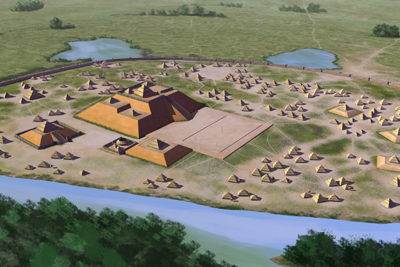
Etowah Indian Mounds (9BR1) are a 54-acre (220,000 m 2 ) archaeological site in Bartow County, Georgia, south of Cartersville. Built and occupied in three phases, from 1000–1550 CE, the prehistoric site is located on the north shore of the Etowah River. Etowah Indian Mounds Historic Site is a designated National Historic Landmark, managed by the Georgia Department of Natural Resources. It is considered "the most intact Mississippian culture site in the Southeast", according to Georgia State Parks and Historic Sites. Both the historic Muscogee Creek and the Cherokee peoples, who each occupied this area at varying times, hold the site to be sacred.
Location
Federal Designation
The National Register of Historic Places, administered by the National Park Service, is the United States federal government's official list of districts, sites, buildings, structures, and objects deemed worthy of preservation for their historical, architectural, archaeological, engineering, or cultural significance. Listing on the National Register recognizes a property's importance to American history but does not place restrictions on private owners; it does, however, make properties eligible for federal historic preservation tax incentives and enables consideration in federal planning decisions. National Historic Landmark designation, the highest level of federal recognition, is reserved for properties that possess exceptional national significance in the history, architecture, archaeology, engineering, or culture of the United States. This property is recorded in the National Register under reference number 66000272. It was listed on October 14, 1966.
Categories
Property data from the National Register of Historic Places, National Park Service (public domain).
Description adapted from Wikipedia under the Creative Commons Attribution-ShareAlike 4.0 International License.
Questions about this property
When was Etowah Mounds listed on the National Register?
Etowah Mounds was listed on the National Register of Historic Places on October 14, 1966.
What type of historic resource is Etowah Mounds?
Etowah Mounds is classified as a site in the National Register of Historic Places.
Is Etowah Mounds a National Historic Landmark?
Yes. Etowah Mounds has been designated a National Historic Landmark (NHL), the highest level of federal recognition for historic properties in the United States.
What is the period of significance for Etowah Mounds?
The period of significance for Etowah Mounds is recorded as the pre_contact era, specifically around 1000.
Can I research the history near Etowah Mounds?
Yes. Aubrey Research reports search National Register listings, battlefield records, land patents, and other primary historical sources within any radius of a US address. A report for an address near Etowah Mounds will include this listing and all other historical records in the area.
Research the history near this site
An Aubrey US report for an address near Etowah Mounds will include this listing alongside battlefield records and other historical sources within your chosen radius.