About this property
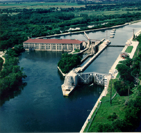
The Lockport Powerhouse is an American run-of-the-river dam used by the Metropolitan Water Reclamation District of Greater Chicago to control the outflow of the Sanitary and Ship Canal and limit the diversion of water from Lake Michigan into the Des Plaines River. The Chicago Sanitary and Ship Canal reached Lockport, Illinois in the 1890s. As part of this construction, a lock and dam was built in Lockport. Seven waste gates, used to control the level of water in the canal and Des Plaines River, were part of this project. From 1903 to 1907, the canal was extended from Lockport to Joliet. Construction on the Lockport Powerhouse began as part of this extension in 1905. Designed by Frederick L. Barrett, the red-roofed Beaux Arts powerhouse was constructed with concrete blocks coursed to resemble stone. The powerhouse featured four Francis-style turbines to generate electrical power, capable of generating 40,000 horsepower (30,000 kW). These turbines have since been replaced with two vertical Kaplan turbines. The powerhouse was also the home of the waste gate controls. The lock and gates were designed to manage a 40-foot (12 m) drop in canal elevation between the two municipalities. A second phase of construction occurred from 1922 to 1933 to handle differing water loads following the opening of the Ohio River Standard Navigation Lock. First operational in 1907, the powerhouse is now recognized as the oldest hydroelectric plant in Illinois. The Lockport Lock, Dam and Power House Historic District was recognized by the National Park Service with a listing on the National Register of Historic Places on March 10, 2004. The lock next to the dam & powerhouse is largely used for barge traffic and has a 39 foot (11.8 meters) drop. It is the second of eight locks on the Illinois Waterway connecting Lake Michigan to the Mississippi River. Belden, David A. (2012). Illinois and Michigan Canal. Images of America. Charleston, SC: Arcadia Publishing. ISBN 978-0738582979. Media related to Lockport Lock and Dam at Wikimedia Commons Inventory of Nonutility Electric Power Plants in the United States 2000 (PDF) National Register of Historic Places (Will County, Illinois)
Location
Categories
Property data from the National Register of Historic Places, National Park Service (public domain).
Description adapted from Wikipedia under the Creative Commons Attribution-ShareAlike 4.0 International License.
Everything a full report reveals about Lockport Lock, Dam and Power House Historic District
This page lists Lockport Lock, Dam and Power House Historic District. A full Aubrey report for an address near it pulls together this listing alongside battlefield records, land patents, and every other historical record within a chosen radius:
Every location is different. Not every section appears for every place, only what the historical record actually holds turns up in a report.
Nearby Battles
Questions about this property
When was Lockport Lock, Dam and Power House Historic District listed on the National Register?
Lockport Lock, Dam and Power House Historic District was listed on the National Register of Historic Places on March 10, 2004.
What type of historic resource is Lockport Lock, Dam and Power House Historic District?
Lockport Lock, Dam and Power House Historic District is classified as a district in the National Register of Historic Places.
What is the period of significance for Lockport Lock, Dam and Power House Historic District?
The period of significance for Lockport Lock, Dam and Power House Historic District is recorded as the listed era.
Can I research the history near Lockport Lock, Dam and Power House Historic District?
Yes. Aubrey Research reports search National Register listings, battlefield records, land patents, and other primary historical sources within any radius of a US address. A report for an address near Lockport Lock, Dam and Power House Historic District will include this listing and all other historical records in the area.
More in Will County
Historic places, battles, and census history across Will County.
Explore WillCounty ›More historic places in Illinois
Browse all historic places in Illinois.
View Illinoishistoric sites ›Research the history near this site
An Aubrey US report for an address near Lockport Lock, Dam and Power House Historic District will include this listing alongside battlefield records and other historical sources within your chosen radius.