About this property
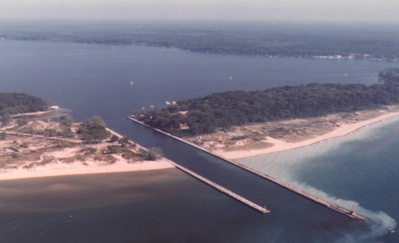
The Navigation Structures at White Lake Harbor are a set of piers protecting the channel connecting Lake Michigan and White Lake, located at the end of Lau Road near Whitehall, Michigan. It was listed on the National Register of Historic Places in 2000. A number of sawmills were established in the White Lake area between 1836 and 1850. Lumber from these mills was rafted through the narrow natural channel between White Lake and Lake Michigan before being loaded on ships. This was a time-consuming process, and the local lumbermen lobbied for an improved waterway. In 1866, an improvement program was funded by Congress. After surveying the area, the construction of a new harbor and channel was proposed. Work on this project commenced in 1867, and by late 1868 the channel was cut and revetments on both sides were in place. Piers extending out into Lake Michigan were gradually extended over the next five years. However, by 1873 it was determined that the original pier design was too short, creating a shoaling hazard, and both piers were extended. In 1875 a lighthouse was constructed along the channel, and in 1887 a life saving station was added. In 1900-01 both piers were again extended, and in 1907 the entire channel and harbor dredged to a deeper depth. A few years later, shipping traffic through White Lake declined considerably, and the Army Corps of Engineers recommended the abandonment of the harbor. However, maintenance continued, with annual dredging, and, in 1936-37, the replacement of the superstructures of both piers with concrete. In 1946 the Life Saving Station was sold and subsequently moved, and in 1970 the lighthouse was sold and converted into a local museum. White Lake Harbor is a man-made channel running through strip of land which separates White Lake from Lake Michigan. The associated navigation structures include three elements: the south pier, the north pier, and the revetments. The north and south piers are parallel to each other, and are 200 feet apart, The north pier is 1717 feet long and the south pier is 1953 feet long. The piers are constructed from a series of piles near the shore, and additional cribs at the end. The entire pier has a concrete superstructure. The revetments were originally of timber pile. A double row of sheet piling was added later, and concrete replaced the timber superstructure.
Location
Categories
Property data from the National Register of Historic Places, National Park Service (public domain).
Description adapted from Wikipedia under the Creative Commons Attribution-ShareAlike 4.0 International License.
Everything a full report reveals about Navigation Structures at White Lake Harbor
This page lists Navigation Structures at White Lake Harbor. A full Aubrey report for an address near it pulls together this listing alongside battlefield records, land patents, and every other historical record within a chosen radius:
Every location is different. Not every section appears for every place, only what the historical record actually holds turns up in a report.
Questions about this property
When was Navigation Structures at White Lake Harbor listed on the National Register?
Navigation Structures at White Lake Harbor was listed on the National Register of Historic Places on May 25, 2000.
What type of historic resource is Navigation Structures at White Lake Harbor?
Navigation Structures at White Lake Harbor is classified as a structure in the National Register of Historic Places.
What is the period of significance for Navigation Structures at White Lake Harbor?
The period of significance for Navigation Structures at White Lake Harbor is recorded as the modern era.
Can I research the history near Navigation Structures at White Lake Harbor?
Yes. Aubrey Research reports search National Register listings, battlefield records, land patents, and other primary historical sources within any radius of a US address. A report for an address near Navigation Structures at White Lake Harbor will include this listing and all other historical records in the area.
More in Muskegon County
Historic places, battles, and census history across Muskegon County.
Explore MuskegonCounty ›More historic places in Michigan
Browse all historic places in Michigan.
View Michiganhistoric sites ›Research the history near this site
An Aubrey US report for an address near Navigation Structures at White Lake Harbor will include this listing alongside battlefield records and other historical sources within your chosen radius.